Tuesday, December 9, 2014

Geographic Changes of Greece to come

The Greek landscape is a very unique one, stemming from many factors from the tectonic plate movement that helped shape the mountains and islands to the coast line that allows for the moderate climate and plentiful rainfall that keeps the landscape lush and green. I will be exploring the changes created by plate tectonics, climate, and the ocean that will occur over the next 10,000 years, 1,000,000 years, and 100,000,000 years.

In the next 10,000 years, the landscape will have small changes, but remain fairly similar to its present day appearance. One difference that will be noticeable is the change of the coastline. The Melissani Cave, which I talked about in my first post, is a sea cave. It was created by the ocean forming a wave cut notch in the weaker stone beneath the more resilient stone, and then carving out the cave make a sea cave. Most likely a sinkhole formed in the middle where the hole in the roof is now, which helped to hollow out the cave and give it shape. More of these will be prevalent in the years to come, as well as sea arches, which are formed much the same way, just without the sinkhole.


Sea arches on the coast of Greece


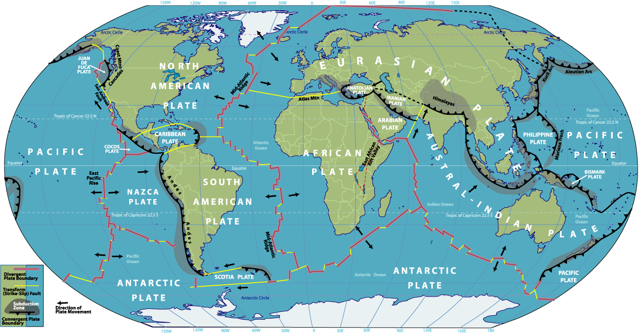
In 1,000,000 years from today the shifting of the tectonic plates will move Greece between 15-30 miles east of its current position; more detail on directionality and speed are covered in the 100,000,000-year section. This may cause more volcanism in the area, as well as other seismic activity that Greece is known for. Since Greece sits on the boundaries and subsequent faults of the Anatolian, Eurasian, Aegean, and African plates, this causes a lot of the earthquakes the country experiences.

Map of the world's tectonic plates and their movement.


100,000,000 years from today will bring extraordinary changes to the area, making it completely different from what it is today. The tectonic plates of the Earth move at a rate of between two and five centimeters per year. Given that the Eurasian and African plates are moving east of the Mid-Atlantic ridge, the Arabian plate is moving northeast, pushing the Anatolian plate northeast as well, Greece will be pushed mostly east somewhere between 1,200 – 3,100 miles. This will be somewhere between the same locations as modern day border between Kazakhstan and China on the closer side, or the Mongolian-Russian border near lake Baikal. The African plate is subducting under the Eurasian and Anatolian plates, which will cause Greece to become a landlocked, mountainous region, similar to what the Himalayas are now, and may even become a replacement of them as they could be worn away by this time. Becoming landlocked and moved so far east will be a huge change in the climate. It will change from the warm, Mediterranean climate to a much colder and arid climate. The Mediterranean will be gone, no longer allowing the water to mediate temperature, and the high altitude will also contribute to the change from a wet climate to an arid climate. This new arid climate will shift the plant and wildlife that live there, and as plant life decreases, there will be less evidence of plant decay on the rocks.


Tectonic plate picture from:

Greek Sea Arches:

Tuesday, October 14, 2014

Hydrology of Greece

Greece has the 11th largest coastline of all countries in the world, and has many rivers running through it, which makes it a perfect place to study and demonstrate the power of hydrology. Hydrology is the study of Earth's water cycle and the distribution of water.

The inland mountains of Greece form a high point that water can flow down from to the coast line; the ultimate destination for rivers. The mountains push the clouds up, forcing them to drop water in the form of rain, and this in turn becomes the rivers that are wide spread across the country. These are well above the water table level, which makes these influent streams. The picture below shows the river basins of Europe, and of those the basins 8 of them are in Greece. Those basins are the Struma, Drin, Vardar, Vijose, Nestos, Velaka, Rezvaya, and Maritsa river basins. The picture second picture gives a better view of the rivers. Most of these rivers end up draining into the Aegean Sea, with only the Drin and Vijose draining into the Ionian Sea. The picture below shows the many rivers that run through the Greek countryside.


This is a picture of the International River Basins of Europe. The Greek river basins are just below the Danube basin and they are shared with Bulgaria, Macedonia, Tirana, and Turkey.


This is a political map showing the rivers of the basins from the above picture. It shows which rivers cross through the multiple countries Greece shares these basins with.


Greece is well known for their volcanoes, and these volcanoes have in turn covered the land, over time, with volcanic soil, or andisols. The andisols along with the many rivers running through the country have been a benefit to the Greek agriculture since the earliest of Greek civilizations and they continue to see this benefit today.


Citations:
Political map pic from:

International River Basins of Europe:


Tuesday, September 16, 2014

The Formation of Greece

Greece is located very close to the boundaries of the Aegean, African, Anatolian, and Eurasian plates of the Earth's crust. The island of Crete is just north of the boundary between the Aegean and African plates where the African plate is subducting beneath the Aegean plate.
A map of the four plates and their boundaries around and through Greece.

A topographical map of Greece and it's surrounding islands
The interaction of these plates has shaped the landscape of Greece in innumerable ways, one of which is the Gulf of Corinth which was formed by the Eurasian and Aegean plates separating. It is one of the most active boundaries in all of Europe, having earthquakes on record of up to magnitude 6.8 on the Richter scale.


Sunday, August 31, 2014

Introduction

I am Mikel Collette, I'm a senior pursuing a degree in Psychology at the University of Colorado at Denver. I've chosen to study the geography of Greece this semester because there are so many geographical forces at play, from the coast of the Mediterranean to the mountains. I am very interested in the geography that have lasted from the ancient Greek civilizations to today, as well as those that have changed.


This is a picture of the Melissani Cave on the Greek island of Kefalonia. It is a beautiful cave that many tourists go, and is referred to in Greek mythology as the Cave of the Nymphs.


image from onebigphoto.com